Map Collections at UCD and on the Web: Historic Maps - All Island Ireland
Pre 1600 Maps of Ireland
Hiberniae, Britannicae Insulae, Nova Descripto by Abraham Ortelius, 1572

Historic Maps of Ireland from the Library of Congress
Ireland from Maps. (1980) Dublin: National Library of Ireland. This publication includes the following maps:
- Ptolemy's Map of Ireland, 150 A.D.
- Martin Waldseemuller : A Seachart of Ireland. Strasbourg, 1513
- Gerhard Mercator : Map of Ireland. Duisburg, 1564
Ireland's History in Maps - this site uses a basic graphical map of Ireland to display thematic information such as Bronze Age Ireland, Arrival of Christianity, the Viking Era, Plantation and Earldoms, etc.
Life in Elizabethan England Shows a basic map of Ireland with the territories owned by the Gaelic chiefs circa 1500.
Early Irish maps from State Papers c.1558 - c.1610 Made available through the National Archives UK website. The collection comprises more than 60 different maps depicting plantations, fortifications and townships in Ireland during the reigns of Elizabeth I and James I, in the 16th and 17th centuries, some which are amongst the earliest cartographic representations of Ireland and are available at a fee.
The Down Survey of Ireland
The Down Survey of Ireland Taken in the years 1656-1658, the Down Survey of Ireland is the first ever detailed land survey on a national scale anywhere in the world. In addition to other material this website comprises digital images of all the surviving Down Survey maps at parish, barony and county level.
Learn about the Down Survey of Ireland project from Dr Micheál Ó’Siochrú of Trinity College Dublin’s Department of History.
How to find the date of the six inch or 25 inch maps
The Irish Townland and Historical Map Viewer allows you view the historic 25 inch and 6 inch mapping series. Instructions are provided in the PDF below and the contents are:
FIND THE RANGE OF MAP SERIES AVAILABLE Page 1
DISPLAY THE TOWNLAND BOUNDARIES Page 3
FIND A TOWNLAND NAME Page 4
VIEW THE DATE OF A MAP Page 6
ADD A MARKER TO YOUR MAP Page 7
VIEW THE ATTRIBUTE TABLE Page 9
FIND THE DATE OF THE FIRST EDITION 6 INCH Page 10
FIND THE DATE OF THE 25 INCH MAPS Page 11
- Finding Townlands and Historic OSi Map DatesThese instructions help you identify and locate townland names in Ireland using the OSi website. 'Irish Townland and Historical Map Viewer'. You can also find historic map sheets, locate them and find their survey dates.
Northern Ireland
- Historical Ordnance Survey of Northern Ireland (OSNI) mapsThis historical maps viewer can be used to search and browse seven historical OSNI maps and four modern basemaps, including aerial imagery. Maps available cover the six counties of present-day Northern Ireland: counties Antrim, Armagh, Down, Fermanagh, Londonderry and Tyrone.
The following map editions are available on the application:
o Edition 1 (1832 – 1846)
o Edition 2 (1846 – 1862)
o Edition 3 (1900 - 1907)
o Edition 4 (1905 - 1957)
o Edition 5 (1919 – 1963)
o 6” Irish Grid (1952-1969)
o 1:10,000 metric Irish Grid (1957-1986)
1831 - 1846 Historic Six Inch Ordnance Survey Maps of Ireland
- You can read about the 6 inch Ordnance Survey maps here.
- OSi MapGenie gives access to the historic 6 inch mapping series. See our MapGenie page for information on access.
- High-quality versions are available to request via an our Request OSi PDF Maps page
This historic 6inch series is available to view on the OSI's free map viewer GeoHive
This two page document shows you how to quickly and easily display the historic 6inch mapping

Ordnance Survey Ireland have issued the guide below on how to use the mapping viewer in GeoHive
- GeoHive Map Viewer User GuideThis guide from Ordnance Survey Ireland issued in October 2021 provides full details on using the GeoHive mapping application
Maps of Ireland after 1600
- Maps of the Escheated Counties of Ireland, 1609This is an atlas containing 31 facsimiles of maps of Ireland ca. 1594-1609. The atlas can be broken down into three sections: Richard Bartlett’s maps of Ulster; the Bodley maps, which cover Fermanagh; Tyrone and part of Derry; Cavan; and Armagh and part of Louth.; and finally, John Thomas’ map of the siege of Enniskillen castle.
- 1610 - The Province of Connaught with the City of Galway describedPrepared for John Speed's 'The Theatre of the Empire of Great Britaine', which was published in 1611/12.
- 1610 - The Province of Leinster with the City of Dublin describedPrepared for John Speed's 'The Theatre of the Empire of Great Britaine', which was published in 1611/12.
- 1610 - The Province of MunsterInsets show the city of Cork and the city of Limerick. Prepared for John Speed's 'The Theatre of the Empire of Great Britaine', which was published in 1611/12.
- 1610 - The Province of Ulster describedPrepared for John Speed's 'The Theatre of the Empire of Great Britaine', which was published in 1611/12.
- 1662 / 1665 - Hibernia Regnvm vulgo IrelandBlaeu Atlas Maior, 1662-5
One of the largest and most splendid of the multi-volume Dutch world atlases. Volume 6 covers Ireland and Scotland. - 1693 - The Kingdom of Ireland : Divided into its ProvincesBy Alexis Hubert Jaillot ; Nicolas Sanson
- 1728 - A Pocket Companion of IrelandBy Herman Moll
- 1770 to 1840 - Longfield Map Collectionby John Longfield, John Brownrigg, Thomas Murray et al, Land Surveyors
The maps are held in the National Library of Ireland and represent all counties in Ireland with the exception of Kerry. Dublin City and County represent more than 44 per cent of all maps. Kildare, Meath and Roscommon are very well represented. There are comparatively few maps of the west and north of Ireland. - 1776 - Maritime Survey of IrelandThis 1776 survey was created by Murdoch MacKenzie and consists of charts of the coast of Ireland.
- 1776 - An Hibernian Atlasby Bernard Scalé. An Hibernian Atlas contains maps of Ireland showing counties, baronies, cities and towns. Each county has its own map with a description on the facing page. The maps are hand coloured. Relief is shown pictorially and roads are shown with topographical information.
- 1777 - Taylor & Skinner's Road Maps of IrelandThe link is to an indexed and fully searchable version of George Taylor and Andrew Skinner's "Maps of the Roads of Ireland", as Surveyed during 1777, containing 288 maps and over 1,100 routes.
Read here for information about Taylor & Skinner's survey.
- Taylor and Skinner - Road Maps of Ireland 1777This website provides an Indexed and fully searchable version - search for a place and then click to view the map. A separate screen shows the route / place on a current Google map.
- 1790 - Map of the Kingdom of Ireland, divided into Provinces, Counties and Baronies [Northern Section]By John Rocque. Engraved in two sections. Showing the Archbishopspricks, Bisshopricks, Cities, Boroughs, Market towns, Villiages, Barracks, Mountains, Lakes, Bogs, Rivers, Bridges, Ferries, Passes, also the Great, the Branch & by post roads together with the Inland navigation &c. Inset map, 23 x 20, The Sea coasts of Great Britain and Ireland.
- 1790 - Map of the Kingdom of Ireland, divided into Provinces, Counties and Baronies [Southern Section]By John Rocque. Engraved in two sections. Top part of this map starts near Galway Bay.
- 1808 - Ireland From The General Gazetteer; or, Compendious Geographical Dictionary1808 Compiled by R. Brookes, Revised by W. Guthrie and E. Jones. Eighth Edition, Dublin
- 1823 - IrelandPublished by Lucas Fielding Jr, Baltimore.
- 1829 to 1842 - First edition Six-inch Ireland1,970 sheets digitised by the National Library of Scotland. Comprehensive, topographic mapping covering all of Ireland from the 1820s to the 1840s.
- 1846 - Lewis's Atlas Comprising the Counties of Ireland, and a General Map of the Kingdom.Samuel Lewis - 32 maps of counties, arranged alphabetically - one map per county. Maps are drawn by R. Creighton and engraved by I. Dower Pentonville London. Includes a note beneath the maps: ”Drawn and engraved for Lewis' topographical dictionary”.
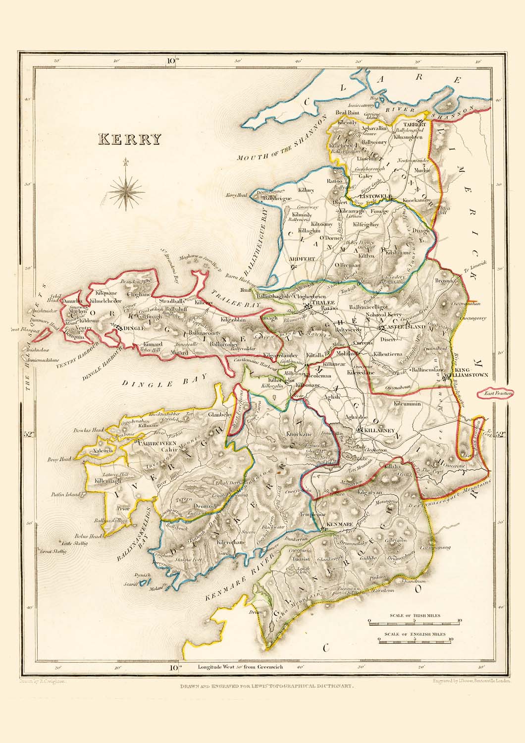
Maps to accompany the Topographical Dictionary - see link above
- Atlas to accompany 2d report of the Railway Commissioners Ireland 18381838. This atlas contains: Map of Ireland to accompany 2d report of the Railway Commissioners showing the varieties of shading and densities of population. -Map of Ireland to accompany 2d report of the Railway Commissioners showing the relative quantities of traffic in different directions. -Map of Ireland to accompany 2d report of the Railway Commissioners showing the relative number of passengers in different directions bt regular public conveyances. -Geological map of Ireland to accompany 2d report of the Railway Commissioners 1837 showing the different lines laid down under the direction of the Commissioners and those proposed by joint stock companies.
- 1844 - IrelandSingle page map of Ireland from Tanner's Universal Atlas with the counties and principal towns & cities shown
- 1847 - Map of Ireland showing quantities of traffic by Henry D HarnessReproduced in the booklet Ireland from Maps, published 1980, Dublin, National Library of Ireland.
- 1847 - Colour Map of Ireland showing Various Public WorksReproduced in the booklet Ireland from Maps, published 1980, Dublin, National Library of Ireland.
- 1847 to 1864 - Griffith's ValuationThis was a full-scale valuation of property in Ireland and is an important source of 19th century genealogical information. It is searchable by family name or place name.
- 1884 - Philip's Handy Atlas of the Counties of IrelandThese were constructed by John Bartholomew, London.
- 1885 Electoral Districts _ Constituency Boundaries for All IrelandOpen this document to get the link to the dataset in shapefile format for the boundaries of both Irish Free State and Northern Ireland. Gives details of the authors / creators of the shapefile, and describes resources they used and the methodology used in GIS to create the shapefile.
- 1895 to 1915 - Military Maps GSGS 3906Click on the link above for online seamless access made available by Map Warper.These military maps were reproduced in the 1940s in Great Britain by the War Office at a scale of 1:25,000 but derived from 1:10,560 county maps published between 1895 - 1918. Most sheets are composites of four six inch maps, photographically reduced with the contours overprinted. The printed sheet maps are held in Richview Library and also the GPEP Map Library.
The GSGS 3906 maps scanned from Trinity College Dublin's collections can also be viewed online
View the index sheet. The full list of Military Maps is here.
- Memorial Atlas of Ireland - 1901Published by L.J. Richards & Company of Philadelphia, the Memorial Atlas of Ireland presents in clear detail the boundaries of each barony and civil parish in the country, county by county.
- 19th century - Irish Historical Geological MapsDisplays a range of historical geological maps, sections and memoirs of the island of Ireland, mostly from the 19th century. Includes a set of full colour 1:63,360 geological maps and a map index for locating the map you require.
- Finding Maps on the Irish Historical Geological Maps WebsiteStep-by-step instructions showing how to find and view a map in the 1:63,360 geological map series.
- 1903 - 1904 - Quarter Inch SeriesPublished by Ordnance Survey Ireland on 16 sheets at the scale of 1:253,440 (¼-inch to 1 mile).
- 1859 - 1917 - One-Inch to the Mile Maps of IrelandThese b&w editions were digitised by the National Library of Scotland. They are laid out on 205 sheets, numbered from north to south. Index is included.
1st edition - 1859-1895
2nd edition - 1898-1909
3rd edition - 1909-1917 - 1899 - 1917 - One Inch to One Mile - ColourThese are topographical maps by Ordnance Survey Ireland. 205 maps are printed on 186 separate sheets (some sheets have more than one map printed on them). Topographic map series of Ireland with relief shown by contours and spot heights. Maps are individually named and carry county names in upper left margin.
- 1938 - EireScale 1:500,000. Map printed with placenames in Irish using old Gaelic script.
- 1940 - Bartholomew Quarter Inch SeriesTake screen prints of this series via the National Library of Scotland's website.
Under Choose an Historic Overlay:
1. Select a Category - Ireland
2. Select a Map Group - Bartholomew Quarter Inch 1940.
- 1940 -1942 GSGS 4136Ireland - This military map series was rapidly compiled during the Second World War from the latest available Ordnance Survey one-inch and half-inch mapping. Roads are classified under 4 headings and coloured accordingly. 1st class road suitable for 2 way convoy traffic, 2nd class suitable for one way convoys, 3rd class suitable for one way light convoy traffic. Roads unsuitable for military traffic were left uncoloured. The maps are gridded and contours are shown.
- Ireland NorthScale 1:500,000. Compiled and drawn by the War Office, Great Britain, 3rd Edition, 1943
Southernmost part of the map shows from Letterfrack in Galway across to Rush in Dublin. - Ireland SouthScale 1:500,000. Compiled and drawn by the War Office, Great Britain, 3rd Edition, 1943. Northernmost part of the map shows from Achill in Mayo across to Dundalk in Louth.
- 1943 - IrelandFull title on map: Ireland (Eire) & Northern Ireland - Special Strategic Map. Prepared by US Army Map Service. Scale 1:1,000,000
- 1950s / 1960s - Ireland - Half Inch SeriesPublished by Ordnance Survey Ireland. Digitised by SABRE. Half-inch to the mile - scale 1:126,720. For some locations there are maps for a couple of different years. (To view the maps : on the left-hand side of the page, left click in the checkbox next to Half Inch and Ministry of Transport maps)
- Ireland North-West - Quarter Inch - Sheet 11960. Published by Ordnance Survey Ireland. Digitised by SABRE. Quarter inch to a mile scale (1:253,440) - metricised to 1:250,000.
- Ireland North-East- Quarter Inch - Sheet 21962. Published by Ordnance Survey Ireland. Digitised by SABRE. Quarter inch to a mile scale (1:253,440) - metricised to 1:250,000.
- Ireland West - Quarter Inch - Sheet 31964. Published by Ordnance Survey Ireland. Digitised by SABRE. Quarter inch to a mile scale (1:253,440) - metricised to 1:250,000.
- Ireland South-East - Quarter Inch - Sheet 41966. Published by Ordnance Survey Ireland. Digitised by SABRE. Quarter inch to a mile scale (1:253,440) - metricised to 1:250,000.
- Ireland South-West - Quarter Inch - Sheet 51966. Published by Ordnance Survey Ireland. Digitised by SABRE. Quarter inch to a mile scale (1:253,440) - metricised to 1:250,000.

This work is licensed under a Creative Commons Attribution-NonCommercial-ShareAlike 4.0 International License