Map Collections at UCD and on the Web: Historic Maps of Dublin
Selection of Images
 |
 |
 |
 |
|
This guide gives step-by-step details on how to find maps on a variety of websites including the David Rumsey collections, UCD Digital Library, the National Library of Ireland and Harvard's Geospatial Library. Updated July 2020. |
St Jude's Parish Map 1864 |
5 ft to 1 Mile 1847 |
GOAD Fire Insurance Map 1893 |
For details on how to find 6inch and 25inch OSi maps scroll down to the bottom of this page to the box named How to find the date of an OSi six inch or 25 inch historic map.
-
Dublin City Surveyors Maps 1695-1827This collection documents the development of the ancient Dublin City Estate within the original walled city and consists of 131 images.
Historic Maps of Dublin
| YEAR | MAP TITLE | MAP MAKER | NOTES | RICHVIEW LIBRARY | OTHER LOCATION / INFO |
|---|---|---|---|---|---|
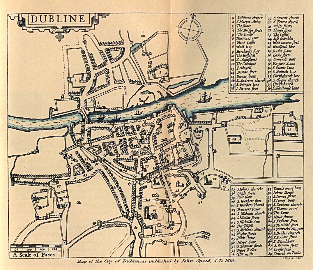
| 1610 | Dubline | John Speed | Held in Trinity College Dublin | Cabinet 2 : Number 8 | Perry Castaneda Library, University of Texas and David Rumsey Map Collection [Dublin shown as inset] |
| 1673 | City and Suburbs of Dublin from Kilmainham to Ringsend | Bernard de Gomme | Held in National Maritime Museum, Greenwich, London | Cabinet 2 : Number 10 | Reproduced in Dublin Part II, 1610 to 1756 (Irish Historic Towns Atlas, no. 19) 2008, Dublin, Royal Irish Academy. Map number 6 |
| 1673 | Plan of Dublin Castle | Held in the Dartmouth Collection of the Staffordshire Record Office, MS D(W) 1778/III/85 | Reproduced in Dublin Part II, 1610 to 1756 (Irish Historic Towns Atlas, no. 19) 2008, Dublin, Royal Irish Academy - Map number 7. Also reproduced in article Seventeenth Century Plans of Dublin Castle by J B Maguire in The Journal of the Royal Society of Antiquaries of Ireland, Vol. 104 (1974), pp. 5-14 | ||
| 1681 - 1851 | Wide Street Commission Map Collection | Wide Street Commission | Type a street name into the search box at top right of the page to find a drawing or map. Use street names of the era, e.g., Sackville Street not O'Connell Street ; Great Britain Street not Parnell Street. | The archives of the Wide Street Commission are held by Dublin City Library and Archive. | |
| 1684 | A Plan of the City of Dublin and Part of the Harbour | Digitised from the British Library's King George III Topographical Collection. | |||
| 1685 | A Draught of the Castle of Dublin at Present | Thomas Phillips | Plan of Dublin Castle, showing Corke Tower, Powder Tower, Gunners Tower and Birmingham's Tower, gardens and moats. | ||
| 1686 | A Map of the Bay and Harbour of Dublin | Greville Collins | Part of the British Library Collection of the Topographical Collection of George III | ||
| 1714 | Dublin | Herman Moll | This link is to the map held by The National Gallery of Ireland. | Dublin is inset on Herman Moll's map of Ireland held in the David Rumsey Map Collection | |
| 1728 | A Map of the City and Suburbs of Dublin | Charles Brooking | This Dublin Port Archive map includes vignettes of Dublin buildings. | Cabinet 2 : Number 12 |
See also Digitised copy from the British Library's King George III Topographical Collection. |
| 1752 | A Survey of the Present Streets Leading from the River Liffey to Dublin Castle | Shows the area prior to the existence of Parliament Street. | Reproduced in Dublin Part II, 1610 to 1756 (Irish Historic Towns Atlas, no. 19) 2008, Dublin, Royal Irish Academy. Map number 15 | ||
| 1756 | An Exact Survey of the City and Suburbs of Dublin | John Rocque |
Link is to 4 maps stitched together by Harvard University Library.
|
Cabinet 2: Numbers 18 to 21 |
Harvard University georeferenced version of this John Rocque map. Also held by Bibliothèque nationale de France |
| 1756 | A Plan of the City of Dublin and the Environs on the Same Scale of London, Paris and Rome | John Rocque | Link is to map held by Harvard University Library. | ||
| 1757 | Pocket plan of the city and suburbs of Dublin : reduc'd from his large plan | John Rocque | Link to a image of the map Reprinted on the Occasion of the Tenth International Conference on the History of Cartography, Dublin, 1983 | Cabinet 2: Number 22 | |
| 1757 | A Survey of the City, Harbour, Bay and Environs of Dublin on the same Scale as those of London, Paris & Rome | John Rocque | Link is to map held by the Bibliothèque Nationale de France | ||
| 1757 | Survey of the city and suburbs of Dublin , with the division of the parishes reduc'd from the large plan in four sheets | John Rocque | Link is to map held by the Bibliothèque Nationale de France | ||
| 1760 | An actual survey of the county of Dublin, on the same scale as those of Middlesex, Oxford, Barks & Buckinghamshires | John Rocque | Link is to map hosted by the Virtual Record Treasury of Ireland website. | Cabinet 2 : Numbers 22 to 26 | Georeferenced version available on South Dublin Historical Mapping website. Select layers icon and click in the checkbox next to the Rocque map. |
| 1764 | Plan de la Ville de Dublin | Jacques-Nicholas Bellin | Link is to map held by the Bibliothèque Nationale de France | Also available in David Rumsey Map Collection | |
| 1767 | Dublin Street Directory Map - a New Plan of Dublin | Compiled for Peter Wilson | Held by Dublin City Library and Archive. | ||
| 1770-1840 | Longfield Map Collection | Maps surveyed by John Longfield ; John Brownrigg and Thomas Murray | The Longfield Map Collection is held in the National Library of Ireland. Dublin City and County represent more than 40% of maps. | The Longfield Maps in the National Library of Ireland : an Agenda for Research by J.H. Andrews published in Irish Geography, Vol 24, Issue 1, 1991. | |
| 1773 | A Survey of the City Harbour Bay and Environs of Dublin on the same Scale as those of London Paris & Rome / by John Rocque with Improvements & Additions by Mr. Bernard Scalé | John Rocque and Bernard Scalé | Held in the UCD Digital Library collection. | Cabinet 2 : Number 30 | |
| 1773 | An Accurate Survey of the City and Suburbs of Dublin / by John Rocque with Improvements & Additions by Mr. Bernard Scalé | John Rocque and Bernard Scalé | Link is to map held by the Bibliothèque Nationale de France | ||
| 1774 | Sketch of the Banks of the Liffey from Dublin to Lucan | John Cleeve Pleydell | Link is to map held by The Royal Collection Trust | ||
| 1780 | A Plan of Dublin | Robert Pool and John Cash | Link is to the map published in the Pool and Cash book on the Internet Archive | Views of the Most Remarkable Public Buildings, Monuments and Other Edifices in the City of Dublin by Robert Pool and John Cash | |
| 1782 | Plan of the city of Dublin : taken from an actual survey from the Universal Scots Almanack | John Robertson | This link is to map held in Harvard University Library | ||
| 1789 | A map and section of that part of the Grand Canal now perfected and also a sketch of the country on each side | Published by John Brownrigg | This link is to one of the Signet Library collection maps held at NLS. | The map includes an inset of the Grand Canal Harbour, Dublin. Chapelizod, Tallaght, Lucan, Palmerstown, Crumlin, etc are also shown. | |
| 1793 | A New Plan of Dublin | Samuel Byron | This link is to map in Trinity College Library. Map printed for William Wilson's Dublin Directory. |
||
| 1797 | A Plan of the City of Dublin |
William Faden | This link is to copy held in The Library of Congress | ||
| 1798 | Engraved by Benjamin Barker for William Wilson Publishers | Includes vignette of The Custom House. Link is to British Library digitised image from page 145 of "Observations on Mr. Archer's statistical survey of the County of Dublin. | |||
| 1800 | New Plan of the City of Dublin | Engraved for Wilson's Dublin DIrectory | This link is to copy in the collections of the American Geographical Society Library, University of Wisconsin-Milwaukee | ||
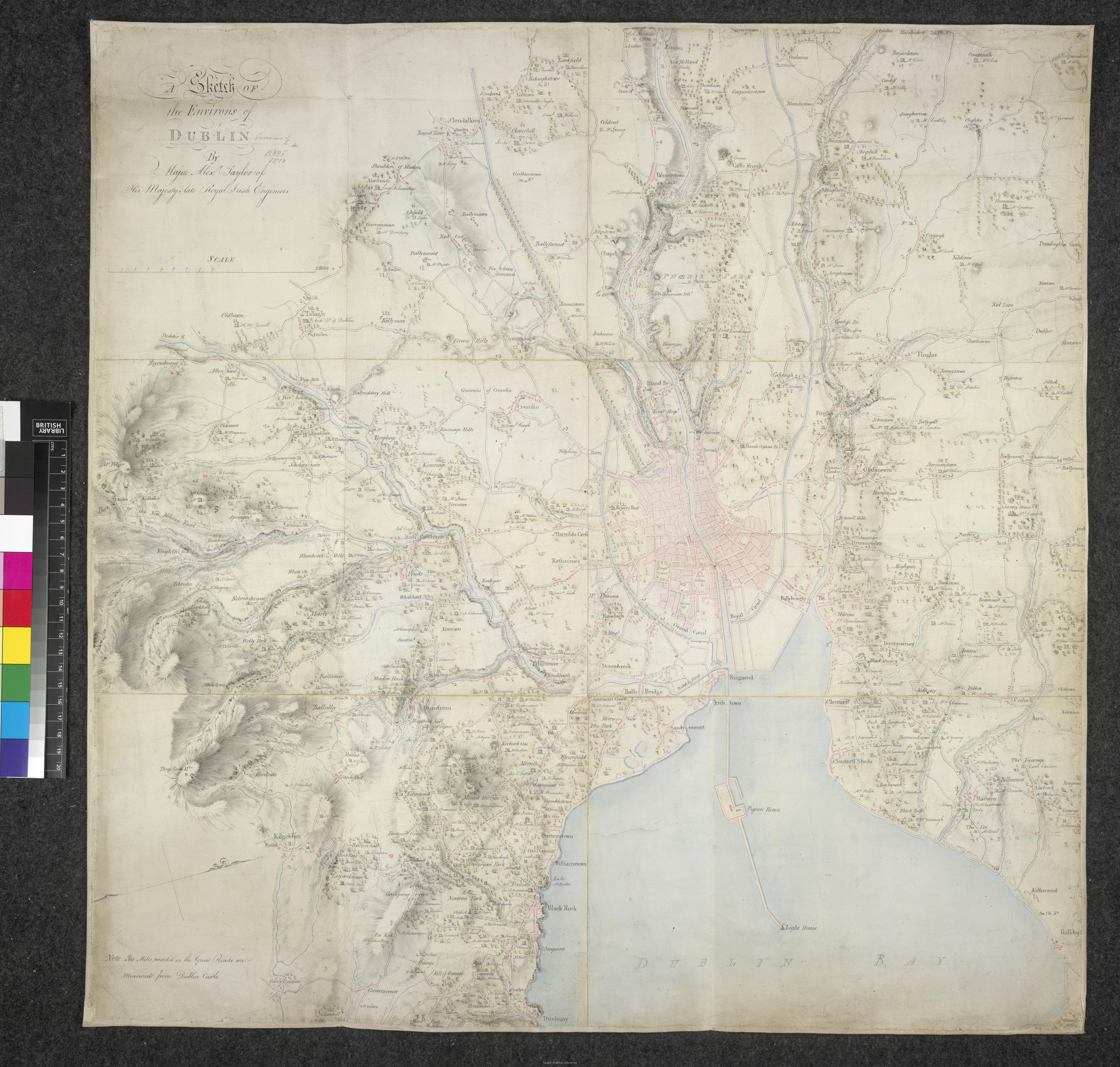
| 1805-1809 | A Sketch of the Environs of Dublin | Alexander Taylor | This link is to map hosted by South Dublin Libraries. The British Library is credited as the copyright owner. | ||
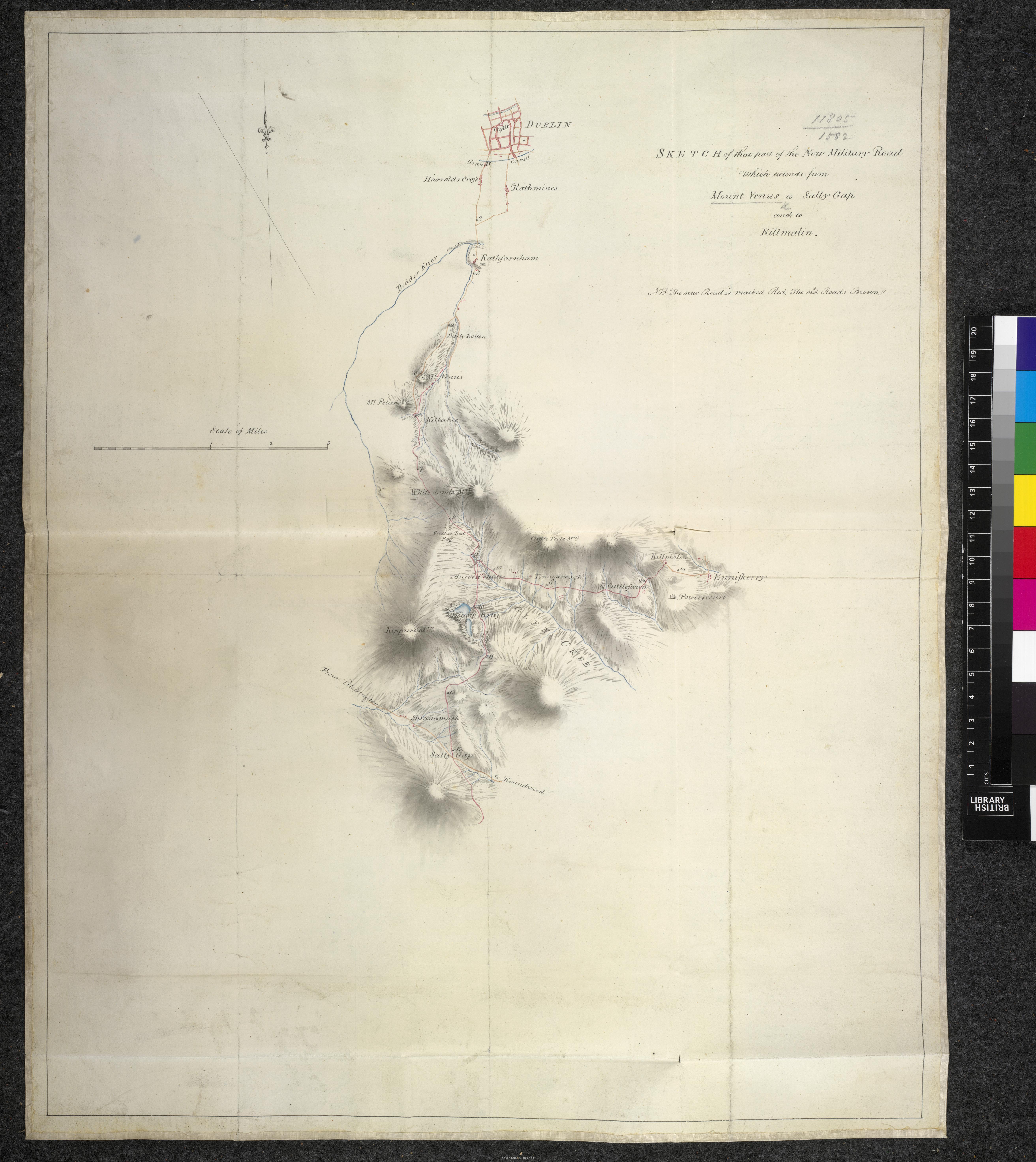
| 1805-1809 | Sketch of that part of the New Military Road which extends from Mount Venus to Sally Gap and to Killmalin | Alexander Taylor | This link is to map hosted by South Dublin Libraries. The British Library is credited as the copyright owner. | ||
| 1810 | An Accurate Plan of Dublin | Nathaniel Jefferys | Link is to digital copy of the book held by National Library of Scotland. Map is printed in Englishman's descriptive account of Dublin, and the road from Bangor ferry, to Holy Head | Hosted online by Falvey Memorial Library, Villanova University, PA, USA. | |
| 1811 | City of Dublin | Thomas Campbell | Cabinet 2 : Number 37 | Reproduced in Dublin Part III, 1756 to 1847 (Irish Historic Towns Atlas, no. 26) 2014, Dublin, Royal Irish Academy. Map number 17 |
|
| 1812 | New and Improved Plan of the City of Dublin | William Corbet for the Society of the Diffusion of Useful Knowledge | This link is to map hosted by Dublin City Library and Archive on Flickr. | ||
| 1816 | Taylor's Map of the Environs of Dublin, Extending 10 to 14 Miles from the Castle | John Taylor |
Taylor's map also available to view via on South County Dublin's map viewer. Select Layers and click in the checkbox next to Taylor's map. |
Cabinet 2 : Number 40 | Extract enlarged and centred on the City area is reproduced in Dublin Part III, 1756 to 1847 (Irish Historic Towns Atlas, no. 26) 2014 Dublin, Royal Irish Academy. Map number 18 |
| 1818 | Plan of Dublin | Link is to map on Internet Archive in History of the City of Dublin, from the Earliest Accounts to the Present Time, by Walsh, Warburton and Whitelaw | Held in UCD Library Special Collections | ||
| 1821 | Map of the County of Dublin | William Duncan | Link is to South County Dublin's map viewer. Select Layers and click in the checkbox next to Duncan's map. | Cabinet 2 : Numbers 42-27 | Colour extract enlarged and centred on the city is reproduced in Dublin Part III, 1756 to 1847 (Irish Historic Towns Atlas, no. 26) 2014, Dublin, Royal Irish Academy. Map number 19 |
| 1822 | Cooke's Royal Map of Dublin | John Cooke | This link is to map hosted by National Gallery of Ireland. Colour map which includes vignettes of Dublin buildings. | Reproduced in Dublin Part III, 1756 to 1847 (Irish Historic Towns Atlas, no. 26) 2014, Dublin, Royal Irish Academy. Map number 20 |
|
| 1836 | Dublin | Drawn by WB Clarke for the Society for the Diffusion of Useful Knowledge | This link is to map hosted by the David Rumsey Map Collection. Includes drawings showing elevations of 14 Dublin buildings. | Cabinet 2 : Number 49 | |
| 1843 | Ordnance Survey | This link is to the National Library of Scotland website. The maps are available as individual sheets. |
Further information about the 1st edition 6inch mapping is given in this Trinity College Library leaflet. The Irish Townland and Historical Map Viewer created by the Ordnance Survey includes the 1st edition 6 inch mapping in a seamless format. This PDF explains how to use the viewer. |
||
| 1837 | The Environs of Dublin | Drawn by BR Davies for the Society for the Diffusion of Useful Knowledge | This link is to map hosted by the David Rumsey Map Collection | Cabinet 2 : Number 51 | |
| circa 1840 |
A Map of Belfield and Belview in the County of Dublin
|
Created for owner Thomas Wallace |
Link is to a tiff file of the map available to download. An early map of part of the UCD campus. Map is featured in the Sept 2008 issue of UCD Today (page 23). |
||
| 1846 | City of Dublin | Smith | A bird's eye-view of Dublin. Open the map and zoom in to see buildings and streets in a 3D view. This panoramic view was published with the Illustrated London News | Reproduced in Dublin Part III, 1756 to 1847 (Irish Historic Towns Atlas, no. 26) 2014, Dublin, Royal Irish Academy. Plate number 10 |
|
| 1847 | Dublin City | Ordnance Survey |
Link is to Ordnance Survey Ireland (OSi) 19th Century Historical Maps hosted by UCD Digital Library. 33 maps cover the area between the two canals. This PPT shows you how to find and download a map. |
Cabinet 2 : Numbers 70 to 102 | |
| 1850 | The Environs of Dublin | Drawn by BR Davies for the Society for the Diffusion of Useful Knowledge. Published by Edward Stanford. | Link is to map hosted by UCD Digital Library | ||
| 1851 | Dublin | Drawn and engraved by John Rapkin and published by John Tallis. | Link is to map hosted by the David Rumsey Map Collection. Includes vignettes of Dublin buildings. | ||
| 1853 | The Environs of Dublin | Drawn by BR Davies for the Society for the Diffusion of Useful Knowledge. Published by George Cox. | Link is to map hosted by Harvard University Library. | ||
| 1855 | Fraser's Map of Dublin and its Suburbs | Reduced from Ordnance Survey map. Printed by Alexander Thom & Sons | Link is to map hosted by UCD Digital Library. | This includes the listing of street addresses. | |
| 1857 | Plan of Dublin | J. Bartholomew, Edinburgh | Link is to map hosted by National Library of Scotland | The map is included in Black's guide to Dublin and the Wicklow mountains | |
| 1857 | Plan of the Ordnance Survey Office; Phoenix Park | Ordnance Survey | Link is to map hosted by the David Rumsey Map Collection. | ||
| 1859 | Fraser's Map of Dublin and Suburbs : with Street References | Reduced from Ordnance Survey Map. Published by McGlashan & Gill | Link is to map hosted by UCD Digital Library. | Street addresses section is missing. | |
| 1864 | Dublin City | Ordnance Survey |
Link is to Ordnance Survey Ireland (OSi) 19th Century Historical Maps hosted by UCD Digital Library. 33 maps cover the area between the two canals. |
Cabinet 2 : Numbers 70 to 102 | |
| 1864 | Maps of the Terenure & Crumlin Estates, Co Dublin | Ordnance Survey | Link is to collection hosted by Dublin City Library & Archive. Eight maps showing properties of Sir Robert Shaw in 1879. The areas covered include Roebuck, Terenure, Crumlin, Templeogue, Rathfarnham, Greenhills, Whitehall, Walkinstown and Kimmage. | Further information is available here: https://www.dublincity.ie/library/blog/maps-terenure-and-crumlin-estates-1879 | |
| 1868 | Dublin and Suburbs | Published by Edward Heffernan | Link is to map hosted on Dublin City Council's Bridges of Dublin historic map collection website | With 22 vignettes of Dublin buildings and street addresses. | |
| 1860s/1870s | Dublin Parish Maps | Ordnance Survey | Originally published at 25 inches to 1 mile. Colour maps. | Held in Richview Library workroom. Search for parish name via UCD Library Catalogue | Approx 80 individual parishes available. Parishes are shown on this map of County Dublin published in the Memorial Atlas of Ireland published by L.J. Richards & Company of Philadelphia, 1901 |
| 1860s to 1890s | Dublin Suburbs | Ordnance Survey |
Link is to Ordnance Survey Ireland (OSi) 19th Century Historical Maps hosted by UCD Digital Library. |
||
| 1874 to 1898 | Maps of Dublin accompanying Thom's Official Directory | Ordnance Survey |
Link is to 9 maps from collection held by UCD School of Geography and digitised by UCD Library. Originally published in Thom's Street Directories. The 1890 map shows the boundaries for the Dublin townships. |
||
| 1875 | Dublin | Adam and Charles Black, Edinburgh | Link is to map within Black's Guide to Dublin and the Wicklow Mountains available online via the National Library of Scotland. | ||
| 1883 | Plan of the City of Dublin | Letts, Son & Co | Link is to map hosted by the David Rumsey Map Collection | ||
| 1893 | Fire Insurance Maps and Plans Dublin | Charles E Goad | Link is to maps on Old Maps Online website. 20 maps for Dublin are published at various scales. |
For more information about the collection please see this introduction. To find the Dublin GOAD maps on the OldMapsOnline website i) click on Explore Maps ii) on the year timeline at the bottom of the screen drag the button to the year 1893 iii) the GOAD maps will display on right side of page. Click on each map to view it. |
|
| 1895 | Map of Dublin Showing Dublin, Wicklow and Wexford Railway Companies 'Loop Line' Connecting all Railway having Termini in Dublin | AT Hennessy | Link is to British Library digitised image from page 24 of "Official Tourist Guide of the Dublin, Wicklow, and Wexford Railway. Illustrated." Hosted on Flickr. | ||
| 1895-1915 | GSGS 3906 Maps | British War Office | GSGS 3906 maps are overlaid on Open Street Mapping. Dublin City and environs - Dunboyne, Bray, Rathcoole, Howth, Rush, Swords, Tallaght et al | Sheets for the entire country are held in Richview Library. See Map Cabinet 18 | These military maps were reproduced in the 1940s in Great Britain by the War Office at a scale of 1:25,000 but derived from 1:10,560 county maps published between 1895 - 1915. |
| 1900 | Plan of the City of Dublin | GW Bacon & Co Ltd | Link is to map hosted by New York Public Library Digital Collections. | ||
| 1907 | Large Scale Map of the City of Dublin and its Environs | MH Gill & Sons |
Link is to map hosted by UCD Digital Library. Tram routes are shown in red on the map. |
||
| 1906 - 1909 | Dublin | Ordnance Survey | Link is to Tailte Éireann GeoHive Map Viewer. Select the MapGenie 25inch basemap. Zoom into Dublin on the map of Ireland. |
Further information about the 25inch mapping is given in this Trinity College Library leaflet. |
|
| 1907 - 1908 | Dublin Sheet 18 Geological Map | Ordnance Survey and Geological Survey of Ireland | Scale 6 inches to 1 mile (1:10,560). Link is to British Geological Survey website |
Some parts of the map are shaded to represent geological types. These annotations made by on the map by the Geological Survey Office in 1901. This is the published accompanying Memoir describing the geology.
|
|
| 1906 - 1909 | Dublin 6inch maps (1:10,560) | Ordnance Survey | This link is to the National Library of Scotland website. The maps are available as individual sheets. | This edition of the Dublin 6inch maps include contours. | |
| 1906 - 1909 | Dublin 25 inch maps | Ordnance Survey | This link is to the individual sheet maps hosted by the Virtual Record Treasury of Ireland. Click on the image to open the map - and click on the arrow to move to the next map in the set. | Cabinet 1 | 16 sheets at a scale of 1:2500 comprising the sheets contained within the Grand Canal and Royal Canals of Dublin. |
| 1908 | Eason's New Plan of Dublin and Suburbs | Eason & Son | This link is to copy in the collections of the American Geographical Society Library, University of Wisconsin-Milwaukee | ||
| 1909 | Dublin | John Bartholomew & Son | Map is hosted by the Internet Archive. Use the + button to zoom in on and enlarge this coloured street map of the central area of Dublin. Scale half inch to one mile. | The map is contained in the guidebook Ireland (Part 1) Northern Counties including Dublin and Neighbourhood by MJB Baddeley. (Click on the magnifying glass to see better image) | |
| 1914 | New Plan of Dublin and Suburbs | GW Bacon & Co Ltd | This link is to copy in the collections of the American Geographical Society Library, University of Wisconsin-Milwaukee | ||
| 1931 | Dublin and District | Ordnance Survey | This link is hosted by Gallica - the digital library of the Bibliothéque Nationale de France. Map scale 1:20,000. County borough indicated by red line. |
||
| c 1935 | Plan of Dublin | Geographica Ltd, London |
Each grid square on the map represents half a mile. Internal details on the map have been used for dating, e.g, at the bottom of the map it reads "...Saorstat Erieann" (sp.) Saorstat Eireann was dissolved in December 1937 and replaced by Éire. |
Original print map held in UCD Library Special Collections | |
| 1936-37 | Dublin | Ordnance Survey | This link is to map hosted by Map Warper. Sheet 22 Scale 1:10,560. Covers area which includes Rathfarnham, Dundrum, Greenhills, Terenure, Templeogue, Windy Arbour, Churchtown, Sandyford, Goatstown, Edmondstown, Taylor's Grange, Ballyboden | Cabinet 1 | |
| 1948 | Plan of Dublin | Geographica Ltd., London | Each grid square on the map represents half a mile. The map shows the Dublin city boundary and also the ward boundaries. | ||
| 1952 | Dublin Popular Edition | Ordnance Survey Office | Published at scale 1:25,000. Link is to American Geographical Society Digital Map Collection at University of Wisconsin, Milwaukee | ||
| 1966 | Satellite Image of Dublin hosted by SOAR Earth Atlas | Space from Space | One of 450 interactive declassified spy satellite images taken between 1960 to 1984 |
See also: |
|
| 1972 | 9th Popular Edition : Dublin City North and South | Ordnance Survey | Link is to map hosted by Princeton University Library. Published at scale 1:18,000. | ||
| Dublin Historic Maps | OpenStreetMap (OSM) | This links out to another website portal which provides images of Dublin maps, ranging from the 1700s to the mid-20th century. Includes maps showing administrative boundaries, e.g. townships, baronies, wards, parishes, etc, |
-
Dublin City Surveyors Maps 1695-1827This collection documents the development of the ancient Dublin City Estate within the original walled city and consists of 131 images.
How to find the date of the six inch or 25 inch maps
The Irish Townland and Historical Map Viewer allows you view the historic 25 inch and 6 inch mapping series. Instructions are provided in the PDF below and the contents are:
FIND THE RANGE OF MAP SERIES AVAILABLE Page 1
DISPLAY THE TOWNLAND BOUNDARIES Page 3
FIND A TOWNLAND NAME Page 4
VIEW THE DATE OF A MAP Page 6
ADD A MARKER TO YOUR MAP Page 7
VIEW THE ATTRIBUTE TABLE Page 9
FIND THE DATE OF THE FIRST EDITION 6 INCH Page 10
FIND THE DATE OF THE 25 INCH MAPS Page 11
See also the National Townland and Historical Map Viewer - User Guide created by Tailte Éireann. This guide explains how to use the transparency and swipe tools.
-
Finding Townlands and Historic OSi Map DatesThese instructions help you identify and locate townland names in Ireland using the OSi website. 'Irish Townland and Historical Map Viewer'. You can also find historic map sheets, locate them and find their survey dates.

This work is licensed under a Creative Commons Attribution-NonCommercial-ShareAlike 4.0 International License